Pining for the White Mountains

Of the places I visit when I am in California, the bristlecone pine groves high in the White Mountains call me back most often. Usually I spend several months during the New Zealand winter camping and hiking in the mountains and deserts of the western United States. Last year, Covid put paid to that. Probably this year, too.

These trees survive in a hostile environment, a high altitude desert, growing ever so slowly. They die slowly, too. Standing trees may be thousands of years old and fallen timbers thousands more.

Dead bristlecone in the Schulman Grove, White Mountains, CA

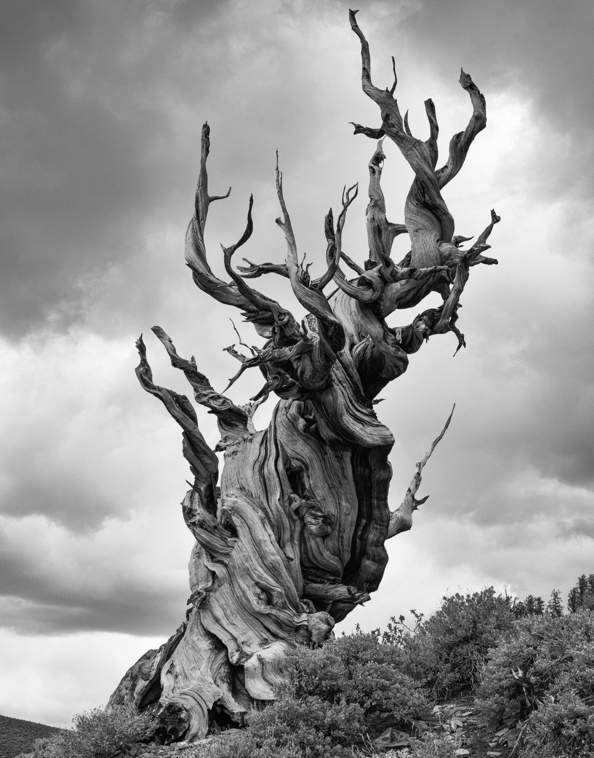
I made a photo book of these trees last year, a tribute to my heroes of the plant world, using images I have made over a number of years. I love the gnarled and twisted branches that reflect the hardships endured by trees growing at such high altitudes and subject to extremes of weather.

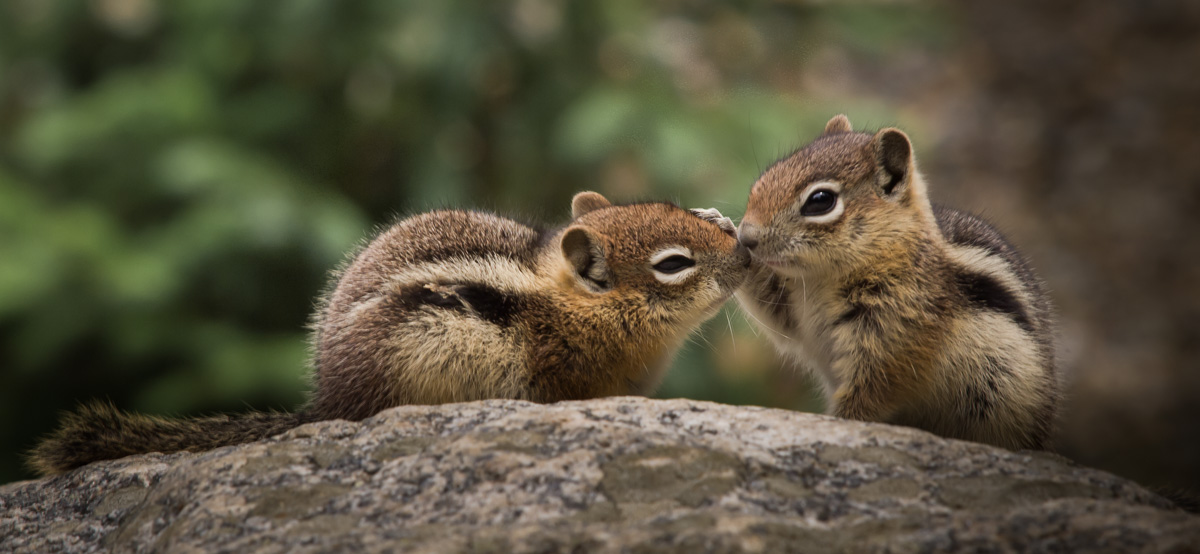
A few animals survive here too. The golden mantled ground squirrel can be found scavenging for cones in summer. In winter these small mammals hibernate to escape the cold. Clark’s nutcracker also feeds on seeds from these trees.

Young golden mantled ground squirrels
Clark’s nutcracker

As bristlecone trees age, their protective outer bark becomes eroded so that eventually the cambium layer beneath can no longer function to transport water and nutrients through the tree. Many very old trees have just a narrow strip of bark connecting their roots to the canopy above, a lifeline that ensures their survival for maybe many years more.

Eroded trunk of bristlecone pine tree
Snow is late to leave the bristlecones at this altitude of close to 12 000 feet (3500 metres)

Apart from the harsh climatic conditions endured by these trees, they grow on thin, limestone soils, which are very low in nutrients. These factors combine to make bristlecones in the White Mountains grow very slowly indeed so that they are the oldest trees in the world, some over 5000 years old.

Bristlecone pine tree in the Schulman Grove growing out of rock

Snow Farm, Wanaka, New Zealand

While I was staying in Wanaka, I visited the Snow Farm to go for a walk. The ski field was closed because there was insufficient snow for skiing so we saw very few other people. Several groups had brought bicycles to cycle along the tracks, which were above the cloud layer shrouding the valleys below. I was surprised how much development there had been since my last visit, which admittedly was probably a couple of decades ago.Snow Farm is a centre for cross country skiing unlike the other ski areas in the area, and boasts stunning views of the Pisa Range. The ski field operates back country huts which are very popular, making it possible to do multi day hikes on skis.

Adjacent to the ski field is a vehicle testing area known as the Southern Hemisphere Proving Grounds. Here, winter testing facilities are provided for automotive companies from all over the world. These facilities are behind a big fence and the associated structures have grown substantially more than buildings on the ski field since my last visit. It appears to be a highly successful operation. However, snow and ice being in short supply, it is likely to be a few weeks before the facility is operating. Normally it is open from June to September each year.

West Coast, South Island of New Zealand

I have just been over to the West Coast for a couple of weekend trips. It is appealing to those of us living in Christchurch to experience the contrast between the two coasts. While Canterbury is dry, the West Coast is usually very wet. The sea is calm on our side, with plenty of swimming beaches. On the Coast, it is rough, often a boiling cauldron that deters anyone from approaching, let alone entering the surf. Even under deceptively calm conditions there are strong undertows, swirling currents and rogue waves that have caught many unawares.

The Surge Pool at Punakaiki’s Pancake Rocks
Mt Cook and Mt Tasman from Revell Street, Hokitika

My two weekends were contrasting, too. Hokitika was so clear and sunny that New Zealand’s highest peaks, Mts Cook and Tasman, stood out from afar. The sky was overcast while were staying in Punakaiki, with the odd light shower of rain. It was pleasant enough to be outside photographing most of the time, though; nothing like the ferocious storm that battered the East Coast, wrecked bridges and roads, inundating farmland and urban areas alike while we were blissfully unaware of the devastation happening on the opposite coast. Christchurch generally receives 650 mm rain each year; this figure is 3000 mm on the West Coast. During the storm, touted as a one in a hundred year event, Christchurch received 150 mm in just 3 days, while in the hill country behind the city rainfall was more than 500 mm during the same period. The rain has now stopped, but rivers continue to run high and cleaning up and repair work has barely begun. I am still waiting to find out whether the roads will be open for my next trip out of town.

Recently a friend introduced me to a slow motion app for my phone, which I played while I was away, trying to discover what works and what doesn’t. This is still a work in progress, but here are two examples, the first from Hokitika, the second from Punakaiki.

Hokitika sunset
Punakaiki surf